









Baltic Sea under prolonged storm regime as severe winter weather persists until New Year’s Eve
The Baltic Sea region is entering a period of prolonged and highly unstable winter weather, with severe storms, snow squalls and gale-force winds expected to affect maritime operations from Monday through at least New Year’s Eve. Forecast analyses indicate that the situation will not be limited to a single frontal passage but will instead evolve into a multi-day storm regime, posing sustained challenges for shipping, ports and coastal communities.
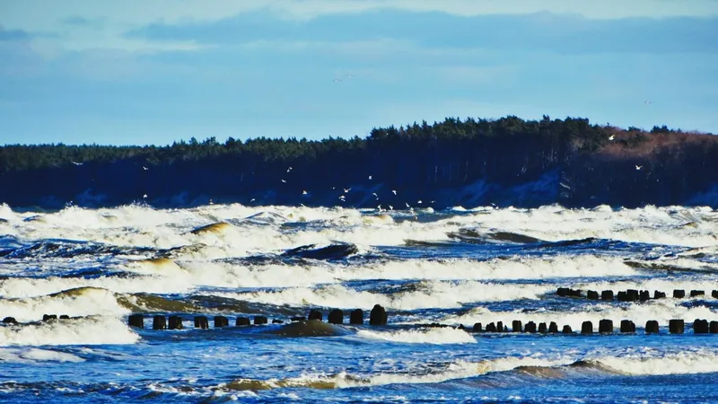
In brief
Wind gusts of up to 120 km/h are forecast on the Polish coast and the open Baltic from Monday evening to Tuesday morning, with 100 to 110 km/h in a wider zone. Meteorologist Mariusz Jasłowski of meteo24.com.pl expects a wave-like low-pressure system, snow storms and stormy weather lasting until New Year's Eve. The most difficult conditions on 31 December will affect the western coast, including Świnoujście, Kołobrzeg and Koszalin. Ferry services may be suspended, fishing vessel departures restricted and SAR services placed on heightened alert.
Deep low-pressure system driving severe conditions
At the core of the situation lies a rapidly deepening low-pressure system moving across Northern and Central Europe. The system is being continuously reinforced by cold Arctic air masses flowing southward and moist maritime air over the Baltic, resulting in a steep pressure gradient and intense atmospheric instability.
According to Mariusz Jasłowski, meteorologist and editor-in-chief of meteo24.com.pl, speaking to Daily Mare, this setup is particularly concerning from a maritime perspective.
Mariusz Jasłowski notes that this is not a short-lived weather event, the pressure system will remain active for several days, producing repeated phases of strong winds, convective snow showers and dangerous sea states. For maritime operations, persistence is the key risk factor in this scenario.
Snow squalls and winter thunderstorms over the Baltic
One of the most critical hazards expected during this period is the development of snow squalls and winter thunderstorms, especially over open waters and coastal zones. These convective systems can form rapidly and intensify within minutes, bringing sudden wind gusts well above forecast averages, near-zero visibility due to heavy snow or graupel, localized electrical activity and abrupt sea-state deterioration.
Mariusz Jasłowski warns that snow squalls at sea are extremely dangerous, as they combine strong gusts with sudden loss of visibility, meaning navigation conditions can change dramatically in a very short time.
Such conditions are particularly hazardous in port approach channels, traffic separation schemes and near offshore installations.
Storm-force winds reaching up to 120 km/h
The most intense phase of the storm is expected from Monday evening into Tuesday morning, when wind gusts along the coast and over exposed marine areas may reach 100 to 110 km/h, with local peaks up to 120 km/h. While wind speeds may fluctuate later in the week, forecast models indicate that strong to gale-force winds will persist, maintaining a high-energy sea state.
This wind regime is expected to generate steep, short-period waves typical for the Baltic, heavy strain on mooring systems in exposed ports, increased risk of overtopping along breakwaters and quays, and difficult manoeuvring conditions for vessels entering or leaving harbour.
Weather impact shifts westward by New Year’s Eve
As the week progresses, the most active frontal zones are forecast to shift westward, placing the western Polish coast under the greatest impact on 31 December. Coastal cities such as Świnoujście, Kołobrzeg and the wider Koszalin region may experience the harshest conditions during the New Year’s Eve period.
Mariusz Jasłowski points out that while the entire Baltic coast will remain affected, the western sector is likely to face the strongest winds and the most persistent snowfall around New Year’s Eve.
For coastal communities, this raises concerns over power disruptions, transport delays and localized flooding linked to storm surge and wave action.
Operational consequences for shipping and ports
The extended duration of the storm significantly increases operational risks. Port authorities, shipping operators and offshore service providers should anticipate repeated disruptions to ferry services, restrictions on pilotage and port entries, delays in cargo handling and offshore operations, and elevated demand for maritime rescue readiness.
Ice accretion on vessels and port infrastructure may further complicate operations, particularly during prolonged exposure to strong winds and freezing precipitation.
A call for caution through year’s end
Maritime experts stress that the coming days demand heightened situational awareness and conservative decision-making. Continuous monitoring of updated forecasts and marine warnings will be essential, as conditions may evolve rapidly.
Mariusz Jasłowski concludes that winter storms on the Baltic are unforgiving, and when severe weather persists for several days, fatigue and infrastructure stress become just as dangerous as the storm itself.
Improvement in conditions is not expected before early January, meaning operators should plan for extended weather-related constraints rather than a rapid return to normal operations.
Source: Gazeta Morska · Compiled by: Kamil Kusier
Related articles
 Safety and rescue Polish SAR’s new rescue vessel Mistral launched at Kewatec in Finland
 Safety and rescue Icelandic Coast Guard and police delegation visits Polish Border Guard’s Maritime Division
 Safety and rescue Polish Navy helicopter evacuates man from Baltic platform 100 km off Władysławowo
 Navy and defence SNMG2 joins Allied warships in PASSEX as Italy's Mare Aperto 2026 gets under way
 Safety and rescue From lightships to solar power: 160 years of the Grundkallen light station
 Education 254 people, manikins and life rafts: Maritime University of Szczecin joins national CPR record attempt
Comments (0)
The discussion is moderated by the editors: a comment appears after review. Your e-mail address is not published.
Nobody has commented on this article yet.