









Türkiye advances indigenous GNSS ambitions: what FGN-100-D3 means for the maritime sector
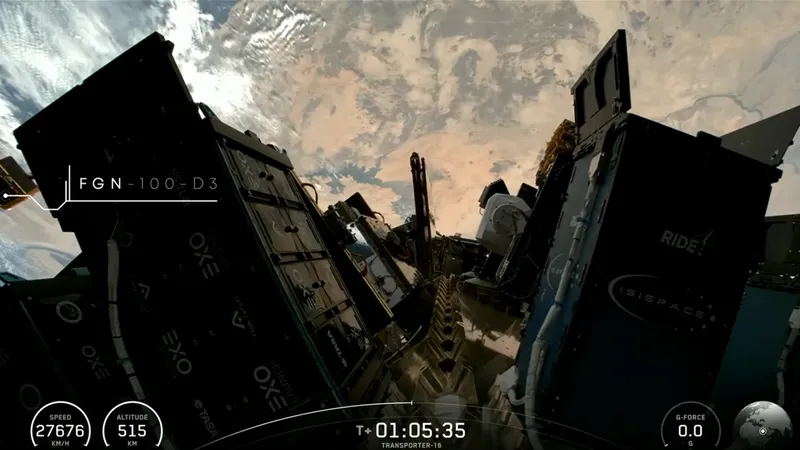
The launch of the FGN-100-D3 test satellite by Fergani Space marks another step in Türkiye’s bid to develop an independent satellite navigation capability—an effort with potential implications for global maritime operations. The satellite was deployed on 30 March 2026 as part of SpaceX Transporter-16, reflecting the growing role of commercial launch platforms in enabling new entrants to the space domain.
In brief
Turkish company Fergani Space launched the FGN-100-D3 test satellite on 30 March 2026 as part of the SpaceX Transporter-16 mission, lifting off from Vandenberg Space Force Base. The 113 kg satellite was placed in low Earth orbit at an altitude of around 500 to 520 km. Fergani Space's Uluğ Bey project envisages building a constellation of more than 100 satellites providing independent navigation and communication services. For shipping and ports, alternative constellations mean greater resilience to GNSS interference and diversification of navigation data.
Strategic redundancy in maritime navigation
Modern shipping relies heavily on satellite-based positioning, navigation and timing (PNT), primarily through systems such as GPS and Galileo. However, increasing concerns over signal disruption—including jamming and spoofing in geopolitically sensitive waters—have accelerated interest in alternative and complementary systems, including BeiDou.
In this context, Fergani Space’s “Uluğ Bey” programme aims to deploy a constellation of more than 100 satellites, offering independent navigation and communications services. For the maritime sector, such developments could enhance redundancy, improve signal resilience, and diversify sources of navigation data.
Operational implications for shipping and ports
While still at an early stage, the emergence of additional GNSS providers could influence maritime operations in several ways:
- Enhanced resilience against GNSS interference, particularly in congested or high-risk regions
- Improved coverage and signal availability, especially in underserved maritime corridors
- Integration opportunities with Vessel Traffic Services (VTS) and port digitalisation frameworks
- Long-term cost competition in satellite-based navigation services
As autonomous shipping and smart port ecosystems evolve, access to multiple reliable PNT sources is expected to become increasingly critical.
Indigenous technology and capability building
The 113 kg FGN-100-D3 satellite was inserted into low Earth orbit (LEO) at approximately 500–520 km following launch from Vandenberg Space Force Base. According to the company, key onboard systems—including attitude control components and navigation sensors—have been developed in-house.
This reflects a broader strategy to establish vertically integrated capabilities across satellite design, avionics, and, eventually, launch systems. Such an approach aligns with global trends in the “New Space” sector, where national and private actors seek greater control over critical infrastructure.
Ambition versus execution
The plan to deploy a 100+ satellite constellation within five years is ambitious and will require significant financial, industrial, and regulatory capacity. Nevertheless, the trajectory mirrors similar efforts by emerging space actors aiming to secure technological sovereignty and strategic autonomy.
For maritime stakeholders, the key question will be whether new systems can meet the stringent requirements for accuracy, reliability, and interoperability necessary for safety-critical navigation.
Although the FGN-100-D3 mission does not immediately alter the global GNSS landscape, it signals a continued shift toward a more diversified and multipolar navigation environment. For shipping companies, port authorities, and maritime technology providers, this trend underscores the importance of monitoring emerging PNT systems and preparing for a future in which navigation data is sourced from a broader array of satellite constellations.
Source: Gazeta Morska · Compiled by: Kamil Kusier
Related articles
 Energy and offshore Equinor takes over Bałtyk 2 and 3 O&M base in Łeba. Port to serve 1.44 GW of offshore wind for 30 years
 Navy and defence Port Gdański Eksploatacja secures NATO NCAGE code. Gdańsk port company lines up for defence tenders
 Shipbuilding industry Ex-Enterprise towed to Mobile under $418.5m contract. Test case for Nimitz-class disposal begins
 Energy and offshore Energa renames Gdańsk gas plant company as foundations for 6,000-tonne turbine and boiler are laid
 Equipment and technology WB Group takes Polish drones from Tokyo to SOFEX in Jordan in a single week
 Ports and logistics PGE books Gdańsk’s T5 terminal for the long haul: Baltica 2 first, then more offshore wind farms
Comments (0)
The discussion is moderated by the editors: a comment appears after review. Your e-mail address is not published.
Nobody has commented on this article yet.