Lasers on the quay: smart docking in the Port of Antwerp-Bruges
In the Port of Antwerp-Bruges, innovation goes hand in hand with safety. A response to the risks posed by the subtle movements of moored vessels is smart docking – a cutting-edge LiDAR-based solution that could transform how ship movements are monitored at the quay.
maritime economy worldwide ports equipment and technology news05 june 2025 | 17:09 | Source: Gazeta Morska | Prepared by: Kamil Kusier | Print
fot. Port of Antwerp-Bruges
Small shifts, big risk
Many of the port’s terminals are located along busy waterways. As Stefaan Ides, a research engineer at the port authority, explains:
– Passing vessels can cause moored ships to shift due to water displacement.
The consequences of such shifts can be serious.
– Even a two- or three-meter movement while a crane is lifting a container can create a hazardous situation. In extreme cases, a vessel might hit a gantry crane or cause a gangway to collapse – adds Mathias Van Laken, port service supervisor.
Shore Tension: active stabilization
One countermeasure is the Shore Tension system – a setup of hydraulic cylinders and additional mooring lines that dynamically stabilize a ship’s position. However, not all vessels are equipped with this system. For those that aren’t, the port authority continuously monitors their position, and the data is shared with pilots to help define safe speed-reduction zones.
GPS: a limited standard
Until recently, GPS units were the standard monitoring tool – powered by a car battery and carried in a large backpack.
– The full kit weighs between five and seven kilos and takes up to 30 minutes to set up – explains Maarten Callens, port supervisor. – Plus, GPS signals can drop out under gantry cranes.
The device had to be mounted at the ship’s highest point, requiring personnel to board the vessel. If a shift was detected, the system sent an automatic alert to port services.
Next-generation monitoring: LiDAR technology
In 2020, the Port of Antwerp-Bruges launched the Smart Docking Challenge, seeking a more effective monitoring system. The winning solution was based on LiDAR sensors – the same type used in automotive applications and infrastructure scanning.
– The device emits a laser pulse that reflects off the ship’s hull. Based on the return time, the system calculates the precise distance to the vessel – says Stefaan Ides.
This enables real-time monitoring of any movement. If a one-meter threshold is exceeded, port authorities are alerted immediately.
Simpler operation, greater safety
The new system is not only accurate but much easier to operate.
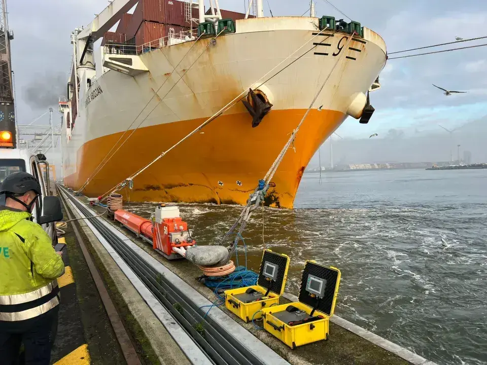
– You simply magnetically attach the unit to a quay bollard, aim it, and power it on – says Maarten Callens.
– We no longer need to board the vessel, which significantly improves control and enforcement procedures – adds Mathias Van Laken.
LiDAR units have already undergone trials across multiple locations in the port, and authorities are optimistic that they will soon fully replace the existing GPS-based systems.
Buy us a coffee, and we’ll invest in great maritime journalism! Support Gazeta Morska and help us sail forward – click here!
Kamil Kusier
redaktor naczelny
comments
Add the first comment
see also
POLSCA S.A. officially launched as Polish ferry operators consolidate on the Baltic Sea
Robert Lewandowski becomes Sunreef Yachts ambassador, orders 80-foot power catamaran built in Poland
Poland’s nuclear project creates new opportunities for regional accommodation sector
Remontowa Shipbuilding to build hybrid passenger-car ferry for Torghatten Midt
Conrad C140 CO.ONE: construction progress*from Gdańsk
Offshore wind boosts energy job market. Demand for maritime and renewable specialists remains strong
Orlen discovers Sissel gas field in the North Sea
The Polish flag: twenty years of drift and a belated change of course. More than just the white-and-red
Jantar Unity ready for service. Is it time for the Polish flag?
Poland as a stable gas supplier for the region and strengthening supply security
ADVERTISEMENT
ADVERTISEMENT