









Lasers on the quay: smart docking in the Port of Antwerp-Bruges
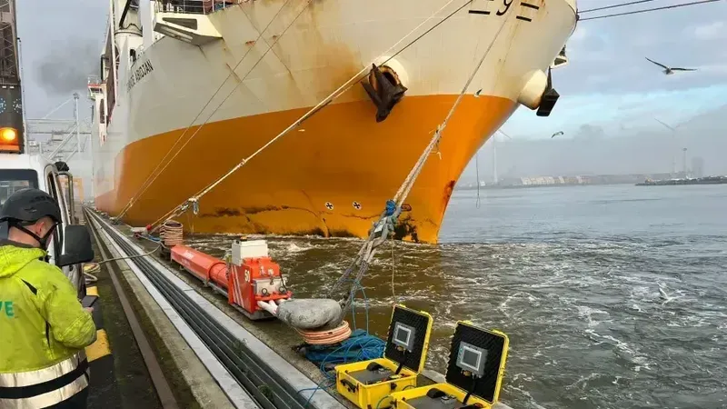
In the Port of Antwerp-Bruges, innovation goes hand in hand with safety. A response to the risks posed by the subtle movements of moored vessels is smart docking – a cutting-edge LiDAR-based solution that could transform how ship movements are monitored at the quay.
In brief
The Port of Antwerp-Bruges is implementing a Smart Docking system based on LiDAR sensors that measure the movements of moored ships in real time. Exceeding a threshold of one metre triggers an immediate alert to port services, and the device is attached magnetically to a bollard on the quay without boarding the vessel. The previous GPS kit weighed 5 to 7 kilograms and took half an hour to set up, as harbour supervisor Maarten Callens explains. The technology was selected in the Smart Docking Challenge competition announced in 2020.
Small shifts, big risk
Many of the port’s terminals are located along busy waterways. As Stefaan Ides, a research engineer at the port authority, explains:
– Passing vessels can cause moored ships to shift due to water displacement.
The consequences of such shifts can be serious.
– Even a two- or three-meter movement while a crane is lifting a container can create a hazardous situation. In extreme cases, a vessel might hit a gantry crane or cause a gangway to collapse – adds Mathias Van Laken, port service supervisor.
Shore Tension: active stabilization
One countermeasure is the Shore Tension system – a setup of hydraulic cylinders and additional mooring lines that dynamically stabilize a ship’s position. However, not all vessels are equipped with this system. For those that aren’t, the port authority continuously monitors their position, and the data is shared with pilots to help define safe speed-reduction zones.
GPS: a limited standard
Until recently, GPS units were the standard monitoring tool – powered by a car battery and carried in a large backpack.
– The full kit weighs between five and seven kilos and takes up to 30 minutes to set up – explains Maarten Callens, port supervisor. – Plus, GPS signals can drop out under gantry cranes.
The device had to be mounted at the ship’s highest point, requiring personnel to board the vessel. If a shift was detected, the system sent an automatic alert to port services.
Next-generation monitoring: LiDAR technology
In 2020, the Port of Antwerp-Bruges launched the Smart Docking Challenge, seeking a more effective monitoring system. The winning solution was based on LiDAR sensors – the same type used in automotive applications and infrastructure scanning.
– The device emits a laser pulse that reflects off the ship’s hull. Based on the return time, the system calculates the precise distance to the vessel – says Stefaan Ides.
This enables real-time monitoring of any movement. If a one-meter threshold is exceeded, port authorities are alerted immediately.
Simpler operation, greater safety
The new system is not only accurate but much easier to operate.
– You simply magnetically attach the unit to a quay bollard, aim it, and power it on – says Maarten Callens.
– We no longer need to board the vessel, which significantly improves control and enforcement procedures – adds Mathias Van Laken.
LiDAR units have already undergone trials across multiple locations in the port, and authorities are optimistic that they will soon fully replace the existing GPS-based systems.
Source: Gazeta Morska · Compiled by: Kamil Kusier
Related articles
 Shipbuilding industry Ex-Enterprise towed to Mobile under $418.5m contract. Test case for Nimitz-class disposal begins
 Maritime economy Poland’s constitutional crisis is also a maritime story
 Safety and rescue Polish SAR’s new rescue vessel Mistral launched at Kewatec in Finland
 Investments Port of Gdańsk opens T5 offshore installation terminal, bringing Baltica 2 logistics home from Bornholm
 Maritime economy Bursztyn Unity to raise the Polish flag, but crew terms remain an open question
 Energy and offshore Bałtyk 2 and 3 offshore wind: all 100 foundations installed, export cables laid
Comments (0)
The discussion is moderated by the editors: a comment appears after review. Your e-mail address is not published.
Nobody has commented on this article yet.