Autonomous mapping of the Cayman Islands’ EEZ: a strategic breakthrough in ocean surveying and maritime security
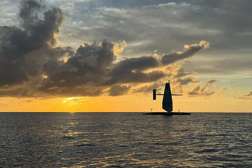
Autonomous surface vessels (USVs) are reshaping the global maritime landscape, redefining how nations map, monitor and secure their waters. A key demonstration of this shift is the Saildrone Surveyor mission completed in 2025: a nearly 300-day, fully autonomous bathymetric mapping of the Cayman Islands’ Exclusive Economic Zone (EEZ), covering roughly 90,000 km².
business maritime economy investments worldwide equipment and technology news05 december 2025 | 08:47 | Source: Gazeta Morska | Prepared by: Kamil Kusier | Print
fot. Saildrone
This was the first instance of a sovereign state commissioning a full EEZ survey using an uncrewed platform equipped with deep-water multibeam sonar. It represents a technological milestone, but also a strategic turning point for maritime governance, defence planning and ocean science.
A new model for maritime domain awareness
At the centre of the mission stands the Saildrone Surveyor, a 72-foot ocean-going USV capable of operating for months without crew or port calls. Equipped with deep-water (Kongsberg EM 304 MKII) and shallow-water (EM 2040 MKII) multibeam sonars, an advanced inertial navigation suite and automated sound-velocity profiling, the platform delivers data quality previously associated with fully crewed research vessels.
Its endurance—nearly ten months at sea—combined with low operating costs and minimal logistics, shows a viable new model for maritime domain awareness (MDA). This is increasingly relevant both for small island states and for larger maritime powers seeking persistent, cost-efficient seabed intelligence.
Operational resilience in a challenging environment
The Cayman Islands’ EEZ combines shallow coastal zones with some of the deepest trenches in the Caribbean, dropping below 7,000 metres. The mission required stable performance amid:
- long-period swell and seasonal storms,
- extensive sargassum blooms capable of interfering with sonar arrays,
- intense biofouling pressure,
- highly variable acoustic conditions affecting multibeam calibration.
Despite these obstacles, the USV maintained operational tempo even in sea state 7, confirming the platform’s resilience during extended missions. The mission also generated new insights into sensor fouling and glider-like autonomous behaviour under environmental stress—knowledge applicable to operations in the Baltic, North Atlantic or Indo-Pacific regions.
Strategic value of high-resolution seabed intelligence
The mission produced the first comprehensive, high-resolution bathymetric dataset for the Cayman Islands’ EEZ. Beyond its scientific relevance, the dataset has wide strategic implications.
Maritime security and defence
Accurate seabed mapping supports:
- protection of subsea infrastructure,
- anti-submarine warfare (ASW) planning,
- mine countermeasures (MCM),
- naval route prediction,
- detection of seabed anomalies or potential threats.
In an era of subsea sabotage and infrastructure vulnerability, autonomous surveys provide persistent awareness without exposing personnel or incurring high operational costs.
Critical infrastructure planning
The Caribbean region is rapidly expanding its subsea cables and offshore energy installations. High-resolution bathymetry informs:
- cable routing strategies,
- seabed stability assessments,
- offshore renewables development.
Fisheries and environmental governance
Precise seafloor data enables informed fisheries management, habitat mapping and the designation of marine protected areas.
Resource exploration
Detailed geomorphology underpins preliminary mineral and geological surveys, including assessments for critical minerals.

Implications for global maritime strategy
The Saildrone mission demonstrates that autonomous platforms can deliver defence-relevant, survey-grade data across extensive maritime areas. This will influence strategic thinking in several domains:
- Hybrid fleet concepts: USVs working alongside crewed vessels in scalable survey networks.
- Strategic autonomy for smaller nations: access to data previously limited to states with major research fleets.
- Rapid post-incident response: autonomous deployments following cable damage or suspected sabotage.
- Cost-optimised maritime domain awareness: persistent data collection at a fraction of the cost of manned operations.
For regions such as the Baltic Sea—where subsea infrastructure, geostrategic competition and offshore energy intersect—these capabilities are increasingly indispensable.
Towards a new era of ocean intelligence
The Cayman Islands project is more than an operational success. It is a blueprint for the next generation of maritime security architecture: a model built on persistent, autonomous, data-driven observation of the underwater domain.
As strategic competition intensifies and the seabed becomes a critical arena for economic and military activity, autonomous USVs are emerging as key assets. Their ability to map, patrol, sense and transmit data continuously will shape the future of maritime situational awareness.
The Saildrone mission demonstrates that autonomous ocean intelligence is no longer a niche capability—it is becoming a strategic necessity.
Buy us a coffee, and we’ll invest in great maritime journalism! Support Gazeta Morska and help us sail forward – click here!
Kamil Kusier
redaktor naczelny
comments
Add the first comment
see also
Navantia and Fincantieri deepen cooperation on the european patrol corvette programme
Galeon Yachts and Meyer Shank Racing: merging luxury yachts with motorsport expertise
Unmanned systems and naval firepower modules. WB Group showcases integrated capabilities at Enforce Tac 2026
Swedish ports record lowest ship calls in 18 years. Implications for the maritime sector
February in Szczecin’s shiprepair sector. Ice, overhauls and North Sea expansion
Advanced ROV trials conducted at CTO to validate subsea technologies for offshore applications
University of Gdańsk and PGZ Naval Shipyard join forces for innovation and security
Stadt Naval to deliver electric propulsion system for Polish rescue vessel Ratownik
Gdańsk port’s Basen Górniczy to gain modern port infrastructure
First month of Jantar Unity operations. Polsca ferry paves the way for Batory program units
ADVERTISEMENT
ADVERTISEMENT