Poland’s eyes over the Baltic Sea. first images from the Polish military satellite and their maritime significance
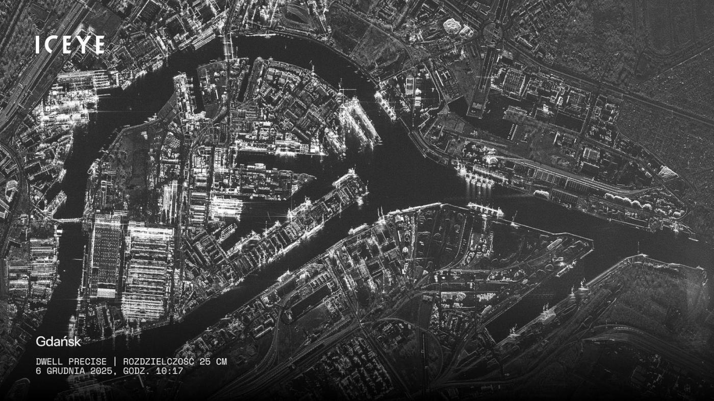
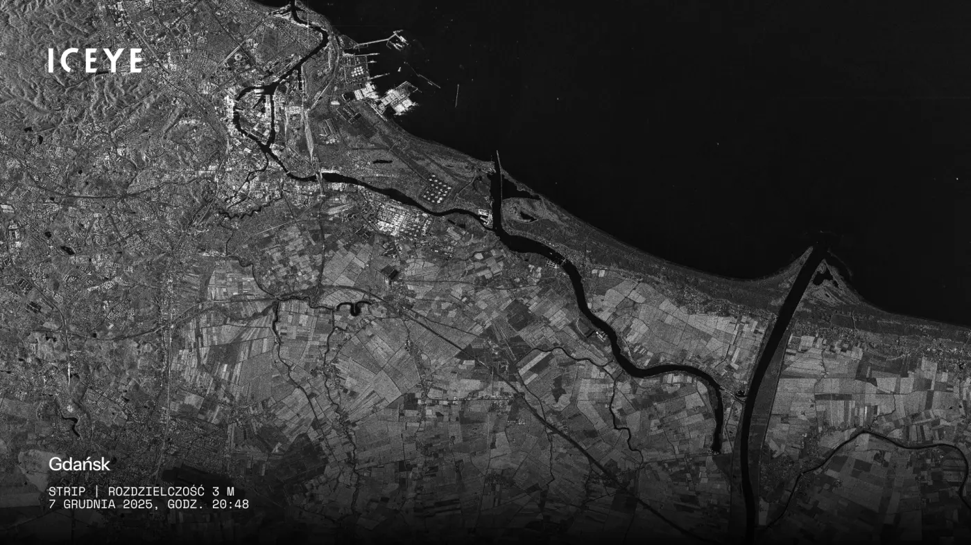
The release of the first satellite images captured by a Polish Armed Forces satellite marks a symbolic and operational milestone for Poland. For the first time, the country possesses its own sovereign space-based reconnaissance capability, enabling independent and continuous observation aligned with national security priorities. Among the locations shown in the inaugural imagery was Gdańsk — a choice that naturally draws attention to the satellite’s relevance for maritime security, ports, shipping lanes and critical offshore infrastructure in the Baltic Sea.
security aviation navy pomerania equipment and technology tricity news09 december 2025 | 07:07 | Source: Gazeta Morska | Prepared by: Kamil Kusier | Print
fot. MON
While the published images serve primarily as a demonstration of capability, their implications go far beyond symbolism. Poland is entering a new phase of maritime domain awareness, moving from reliance on allied or commercial satellite data toward operating its own dedicated observation asset.
Radar imaging and why SAR matters at sea
The Polish military satellite is equipped with synthetic aperture radar (SAR) technology. Unlike optical satellites, SAR systems do not depend on sunlight and are largely unaffected by cloud cover, fog or adverse weather conditions. Instead, they actively illuminate the Earth’s surface with radar signals and analyse the returned echoes.
For the Baltic Sea region, where limited visibility and difficult weather conditions dominate much of the year, this capability is critical. Continuous observation of maritime activity becomes possible regardless of season or time of day — a decisive advantage for both security and safety at sea.
Ports, shipping lanes and critical infrastructure
From a maritime perspective, SAR-based surveillance offers clear benefits in monitoring:
- commercial ports and terminals (Gdańsk, Gdynia, Szczecin–Świnoujście),
- major shipping routes and anchorage areas,
- offshore energy infrastructure, including pipelines, subsea cables and offshore wind farms,
- coastal approaches and port entrance areas.
Radar imagery can detect and track vessels on the water surface, identify unusual movement patterns and reveal anomalies — such as ships operating without AIS signals or unexplained activity near critical maritime infrastructure. In light of recent incidents involving damage or sabotage of subsea assets in the Baltic region, such capabilities have become strategically important.
The Baltic Sea as a high-risk maritime zone
The Baltic Sea can no longer be viewed solely as a commercial or transport waterway. Russia’s war against Ukraine, heightened NATO–Russia tensions and the growing density of offshore energy infrastructure have turned the region into an area of increased strategic risk. Continuous and independent maritime surveillance is now a key pillar of national and regional security.
By operating its own military satellite, Poland gains the ability to set observation priorities, manage revisit times and control the flow of sensitive data — including detailed monitoring of port activity and maritime logistics. This autonomy reduces dependence on external data providers and improves responsiveness during emerging crises.
Beyond military use: dual-use maritime applications
Although formally assigned to the Polish Armed Forces, the satellite’s capabilities extend well beyond purely military purposes. SAR imagery is widely used in civil and maritime applications, including:
- monitoring oil spills and other forms of marine pollution,
- assessing storm damage and coastal flooding,
- tracking shoreline changes and erosion,
- supporting maritime rescue and crisis response,
- environmental protection and spatial planning in coastal zones.
In countries with advanced Earth observation systems, satellite data is routinely shared with maritime administrations, coast guards and port authorities. Poland’s expanding space capabilities may follow a similar trajectory, strengthening cooperation between defence institutions and civilian maritime stakeholders.
Demonstration phase, not full operational readiness
The images released so far originate from an early operational phase. The satellite is still undergoing calibration, testing and system validation before reaching full operational readiness. As these processes progress, image quality, availability and tasking efficiency are expected to improve.
For the maritime sector, this signals that a new and permanent source of high-quality Baltic Sea observation data is emerging — one that may shape future approaches to maritime safety, port security and infrastructure protection.
A step toward maritime and technological sovereignty
Poland’s entry into the group of countries operating military reconnaissance satellites carries both strategic and economic significance. Independent space-based observation enhances resilience, accelerates decision-making and strengthens Poland’s role as a responsible Baltic maritime state.
The first satellite view of Gdańsk is therefore more than a technical achievement. It marks the beginning of a new chapter in how Poland monitors and safeguards its maritime interests. Over the Baltic Sea, a new layer of permanent situational awareness is taking shape — increasingly guided by national capabilities and national priorities.
see also
Buy us a coffee, and we’ll invest in great maritime journalism! Support Gazeta Morska and help us sail forward – click here!
Kamil Kusier
redaktor naczelny
gallery


comments
Add the first comment
see also
Defence.Hub strengthens capabilities in technologies supporting maritime infrastructure security
Damen to build 13 SAR units for Turkey. Strengthening search and rescue in the Aegean Sea
Sebastian Kluska, director of MSPiR SAR: No room for improvisation at sea. Skills and judgment matter
MS Kapitan Poinc to deploy FRB 850 in Baltic SAR upgrade
105th life-saving mission. Naval Aviators conduct double "Heart Action" transport
Another successful medical evacuation over the Baltic Sea. Yet another intervention at offshore wind farms
Fishing trip on Vistula Lagoon cut short due to missing certificates
Drifting tanker near Malta highlights risks linked to the global “shadow fleet”
Cross-border SAR operation on the ice of the Gulf of Bothnia
Body recovered from the waters of Puck Bay near Babie Doły in Gdynia
ADVERTISEMENT
ADVERTISEMENT